Map View From Google Maps
A picture is worth a thousand words. Google’s interactive map enables you to zoom in and out, change mapping features, and get driving directions, for Sonoma Valley.
Home » Planning Your Visit » Where is "Sonoma"?
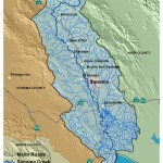
The town of Sonoma is located 45 miles north of San Francisco in the heart of the California wine country. It is the gateway to the scenic 17-mile Sonoma Valley which is cradled between the Mayacamas and the Sonoma Mountain ranges. It runs as far north as the southern edges of Santa Rosa and as far south as the San Pablo Bay.
A picture is worth a thousand words. Google’s interactive map enables you to zoom in and out, change mapping features, and get driving directions, for Sonoma Valley.
Sonoma, The City
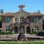
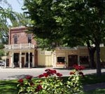
 Technically, it’s named a “City”, but it’s a “Town” by most standards. Developed around an 8 acre central plaza, or town square, over 9,100 people live within the four square miles of the City of Sonoma limits. Modern culture and businesses thrive here among the landmark adobe and historic buildings, an eclectic blend of the past with the present. Sonoma is the largest town in Sonoma Valley. Here numerous cultural events, shows, and celebrations are held in the historic central Plaza year ’round, for the enjoyment of locals and visitors alike. The Plaza offers shaded picnic tables, children’s playground areas, lawns and even a duck pond. The City of Sonoma is situated at the southern end of Sonoma Valley.
Sonoma Valley
 Formed by the Mayacamas Mountains to the east and the Sonoma Mountains to the west, Sonoma Valley stretches approximately 17 miles north to south (longer if you include the flat lands stretching down to San Pablo (San Franciso) Bay. Sonoma Creek runs down the center, emptying into San Pablo Bay. The native Miwok and/or Pomo people coined the name “Sonoma”, thought to translate to “Valley of the Moon”. Jack London popularized the term “Valley of the Moon” in his 1913 book of the same name. Sonoma Valley was the home to the earliest vineyards and wineries in the state and today produces many of world’s most highly appreciated wines. Sonoma Valley includes the City of Sonoma and the small towns of Glen Ellen and Kenwood to the north.
 Glen Ellen
Located mid-way up Sonoma Valley, the hamlet of Glen Ellen boasts a gourmet market and a handful of winery tasting rooms and restaurants. Jack London’s Beauty Ranch is now a State Park, well worth a visit.
 Kenwood
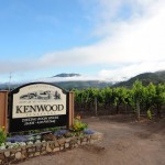
At the north end of the Valley, the village of Kenwood is small, yet packed with attractions. It is home to many world class wineries, beautiful wine country vineyard vistas, and Sugarloaf State Park.
Sonoma County
Sonoma County is big and it is diverse. Roughly the size of Rhode Island, Sonoma County features rugged Pacific Coast line, rich agricultural lowlands, and rugged Coastal Mountain Ranges. Sonoma Valley occupies a relatively small portion of the county, the southwestern corner, bordering Napa County.
Other Sonoma Valley Towns
While Sonoma, Glen Ellen, and Kenwood are the better known towns in Sonoma Valley, there are several other notable communities you will soon hear about while you’re in Sonoma
 Schellville: At the southwestern corner the valley are the farms, vineyards, and wetlands of unincorporated Schellville. Beyond the vineyards, the land stretches out into the wetlands, the sloughs, and the local creek flowing into the San Francisco Bay. Founded in 1888, Schellville was once home to several hay, grain, and other crop farms. Today, most of these fields are covered with vineyards. Schellville is also home of the Sonoma Valley Airport, known for its antique airplanes, and the nearby wineries.
Vineburg: At the southeastern end of the valley, is unincorporated Vineburg. If you are coming from Napa Valley one of the main routes between the two valleys takes you through the Vineburg area. The “downtown” includes a deli and a post office at the intersection of 8th St. East and Napa Rd., along a light industrial area bordered by majestic and fragrant eucalyptus trees. Rural Vineburg is home to several vineyards, wineries, cows, horses, small farms and local families.
Boyes Hot Springs, Fetters Hot Springs, Agua Caliente: Mid-way up the valley, In the 1895′s, natural hot mineral water springs were discovered in the 1890′, sparking the Valley’s hot springs resort heyday, lasting through the 1930s. Today, evidence of the Hot Springs is long gone, but the communities of Boyes Hot Springs, Fetters Hot Springs, and Agua Caliente, remain. The area is still home to several hotels and restaurants and few thousand local families.
Copyright © 2020 BestinSonoma.com, Sonoma, CA. 95476. All rights reserved. Privacy Policy
